 Live Music Archive
 Librivox Free Audio
 Metropolitan Museum
 Cleveland Museum of Art
 Internet Arcade
 Console Living Room
 Books to Borrow
 Open Library
 TV News
 Understanding 9/11
Europe at-a-glance. Third edition.
Item Preview

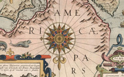
Colored rotating chart of Europe. Third edition. When the user points the arrow at a country name around the circular perimeter, small openings reveal nine different geographical data points about the country: Population per square mile -- Area of country square miles -- Principal river length in miles -- Highest mountain height in feet -- Population of Country -- National colours -- Government -- Standard time to Greenwich noon -- Capital population. Also, within the pointing arrow a number appears for each country - associated with an index number on the map - for connecting the data points with the location. Country names around the perimeter appear in alphabetical order. Includes instructions for use. Map is 22 x 22 cm, placed upon circular base 25 x 25 cm. (Date estimated based upon penciled annotation on verso: Oct. 30th 1930. Author and publisher conjectured based upon other items in series within collection; see Pub List No 14257.000 and 14258.000.)
Colored rotating chart of Europe, published by Frank Pitchford & Co., Ltd. (circa 1930).

